BAGYO UPDATE #LuisPH 🌀 5 a.m., August 3, 2026 More areas…

3 reactions
BAGYO UPDATE #LuisPH 🌀
5 a.m., August 3, 2026
More areas placed under wind signal no. 1 as Luis is almost stationary east of Aurora.
At 4 a.m. Monday, the tropical depression was located 130 km east southeast of Casiguran, Aurora.
It packs winds of 55 kph with gusts up to 70 kph.
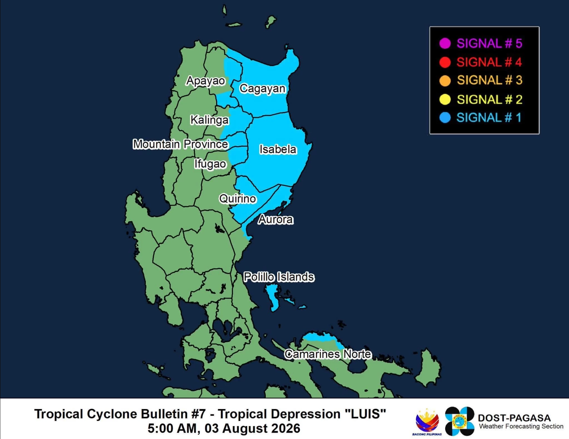
Wind signal no. 1 is raised over
central and eastern Cagayan
Isabela
Quirino
eastern and southern Apayao
eastern Kalinga
eastern Mountain Province
eastern Ifugao
northern Aurora
Polillo Islands
northern Camarines Norte
Luis may pass close to or make landfall over Isabela later tonight or early Tuesday.
It may weaken into a remnant low pressure area by Wednesday before merging with the broader circulation of Typhoon Dolphin.
The tropical depression will bring moderate to heavy rains over Central Luzon, CALABARZON, and parts of Cagayan Valley, Cordillera, and Ilocos Region on Monday and Tuesday.
Heavy to intense rains may be expected in La Union, Pangasinan, Zambales, and Bataan.
From Wednesday, the southwest monsoon enhanced by Typhoon Dolphin will bring significant rainfall over almost the same areas.
Flooding and landslides are expected in many areas.
The public is advised to continue monitoring weather updates and make necessary preparations. #WeatherPatrol
5 a.m., August 3, 2026
More areas placed under wind signal no. 1 as Luis is almost stationary east of Aurora.
At 4 a.m. Monday, the tropical depression was located 130 km east southeast of Casiguran, Aurora.
It packs winds of 55 kph with gusts up to 70 kph.
Wind signal no. 1 is raised over
central and eastern Cagayan
Isabela
Quirino
eastern and southern Apayao
eastern Kalinga
eastern Mountain Province
eastern Ifugao
northern Aurora
Polillo Islands
northern Camarines Norte
Luis may pass close to or make landfall over Isabela later tonight or early Tuesday.
It may weaken into a remnant low pressure area by Wednesday before merging with the broader circulation of Typhoon Dolphin.
The tropical depression will bring moderate to heavy rains over Central Luzon, CALABARZON, and parts of Cagayan Valley, Cordillera, and Ilocos Region on Monday and Tuesday.
Heavy to intense rains may be expected in La Union, Pangasinan, Zambales, and Bataan.
From Wednesday, the southwest monsoon enhanced by Typhoon Dolphin will bring significant rainfall over almost the same areas.
Flooding and landslides are expected in many areas.
The public is advised to continue monitoring weather updates and make necessary preparations. #WeatherPatrol


1

1

1
| 7,000 mlx | |
| 29 | |
| 3 |