Mid-Atlantic Ridge: Earthquakes M≥4.5 Have Reached Their…

0 reactions
Mid-Atlantic Ridge: Earthquakes M≥4.5 Have Reached Their Highest Levels in the Modern Record
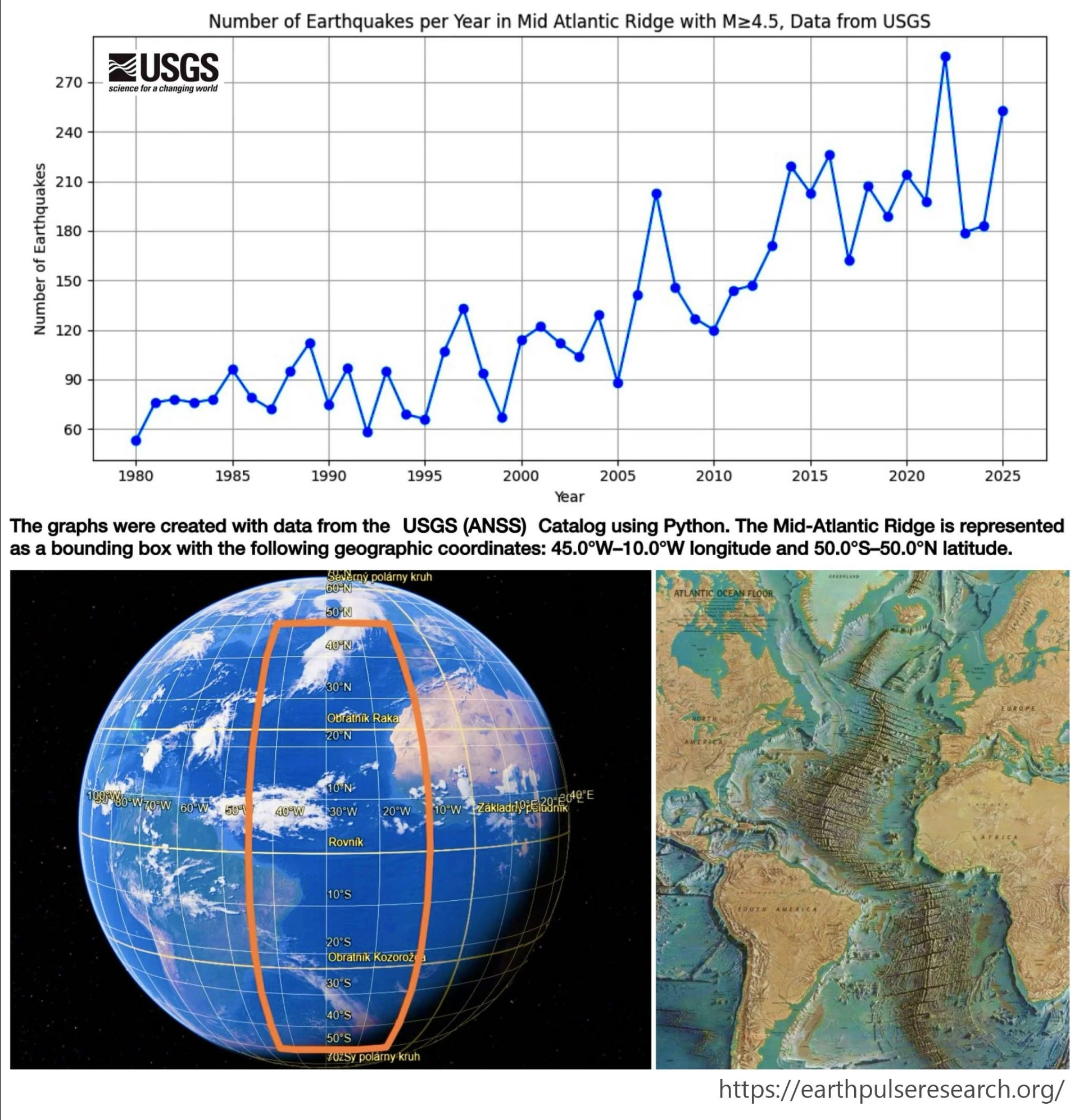
This visualization shows the annual number of earthquakes with magnitude ≥4.5 within a broad section of the Mid-Atlantic Ridge from 1980-2025, together with the analyzed region.
The Mid-Atlantic Ridge is one of the world's largest tectonic structures, extending for more than 16,000 km through the Atlantic Ocean. It marks a divergent plate boundary where new oceanic crust is continuously formed.
**Key observations:**
• Earthquake counts show a clear long-term increase compared with the 1980s and 1990s.
• Several pronounced peaks are visible, including around 2007, 2014, 2016, 2022, and 2025.
• 2025 recorded one of the highest annual totals in the entire time series.
• Many of these peaks coincide with periods of elevated activity that included M6-M7 earthquakes and their associated aftershock sequences.
**Recent context:**
On **June 17, 2026**, a **M6.6** earthquake occurred along the Central Mid-Atlantic Ridge at a depth of approximately 10 km, highlighting the continued seismic activity of this plate boundary system.
**Methodology:**
• **Data source:** USGS Earthquake Catalog
• **Magnitude threshold:** M ≥ 4.5
• **Time period:** 1980-2025
• **Region:** Mid-Atlantic Ridge (bounding box shown on the map)
• **Visualization:** Python
#education
source
This visualization shows the annual number of earthquakes with magnitude ≥4.5 within a broad section of the Mid-Atlantic Ridge from 1980-2025, together with the analyzed region.
The Mid-Atlantic Ridge is one of the world's largest tectonic structures, extending for more than 16,000 km through the Atlantic Ocean. It marks a divergent plate boundary where new oceanic crust is continuously formed.
**Key observations:**
• Earthquake counts show a clear long-term increase compared with the 1980s and 1990s.
• Several pronounced peaks are visible, including around 2007, 2014, 2016, 2022, and 2025.
• 2025 recorded one of the highest annual totals in the entire time series.
• Many of these peaks coincide with periods of elevated activity that included M6-M7 earthquakes and their associated aftershock sequences.
**Recent context:**
On **June 17, 2026**, a **M6.6** earthquake occurred along the Central Mid-Atlantic Ridge at a depth of approximately 10 km, highlighting the continued seismic activity of this plate boundary system.
**Methodology:**
• **Data source:** USGS Earthquake Catalog
• **Magnitude threshold:** M ≥ 4.5
• **Time period:** 1980-2025
• **Region:** Mid-Atlantic Ridge (bounding box shown on the map)
• **Visualization:** Python
#education
source


| 3,000 mlx | |
| 5 | |
| 0 |