
0 reactions
⚠️ ALERT: TROPICAL STORM ‘KIYAPO’ STARTS CROSSING NORTH OF CAGAYAN!
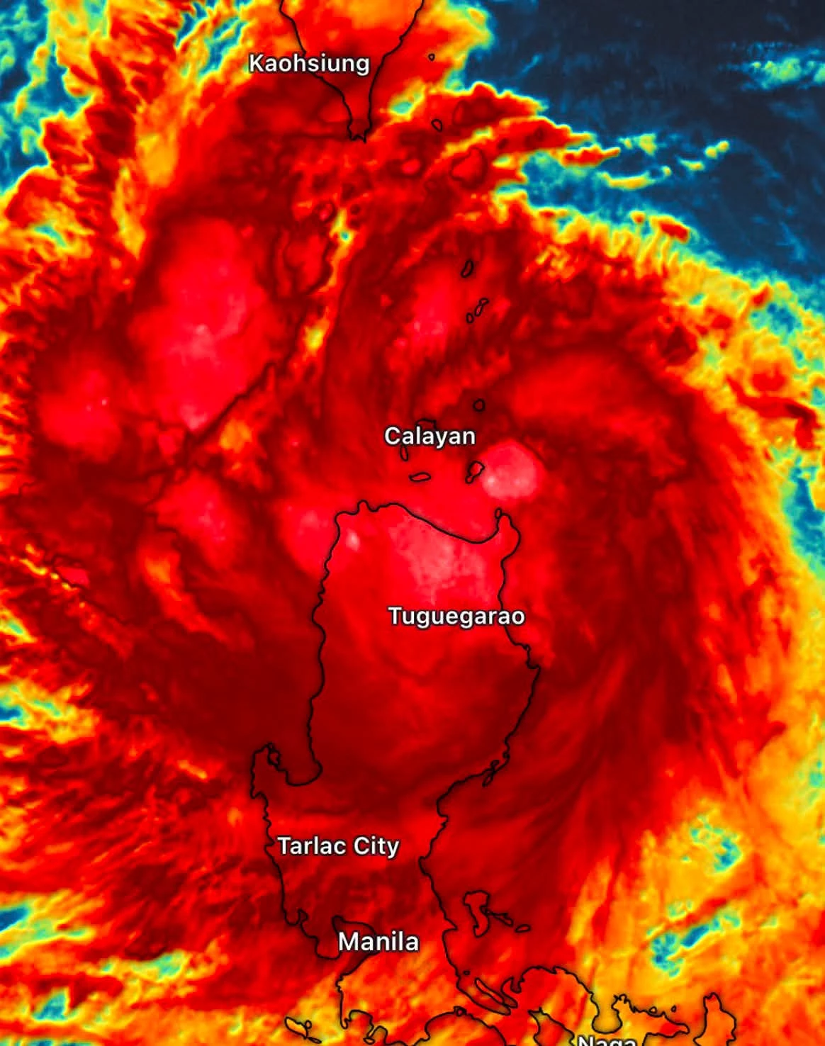
Tropical Storm #KiyapoPH {#NOUL} is beginning to cross the Babuyan Channel north of #Cagayan , bringing heavy rainfall across the Cagayan Valley.
Meanwhile, the rest of mainland #Luzon , including #MetroManila , will experience cloudy to rainy weather.
📸: Enhanced IR HIMAWARI-9 via Windy
#WeatherUpdate | 24 July 2026
Tropical Storm #KiyapoPH {#NOUL} is beginning to cross the Babuyan Channel north of #Cagayan , bringing heavy rainfall across the Cagayan Valley.
Meanwhile, the rest of mainland #Luzon , including #MetroManila , will experience cloudy to rainy weather.
📸: Enhanced IR HIMAWARI-9 via Windy
#WeatherUpdate | 24 July 2026


3 reactions
PHILIPPINES NOW COVERED IN CLOUD BANDS DUE TO TROPICAL STORM 'KIYAPO' AND SOUTHWEST MONSOON (HABAGAT) 🌀⚠️
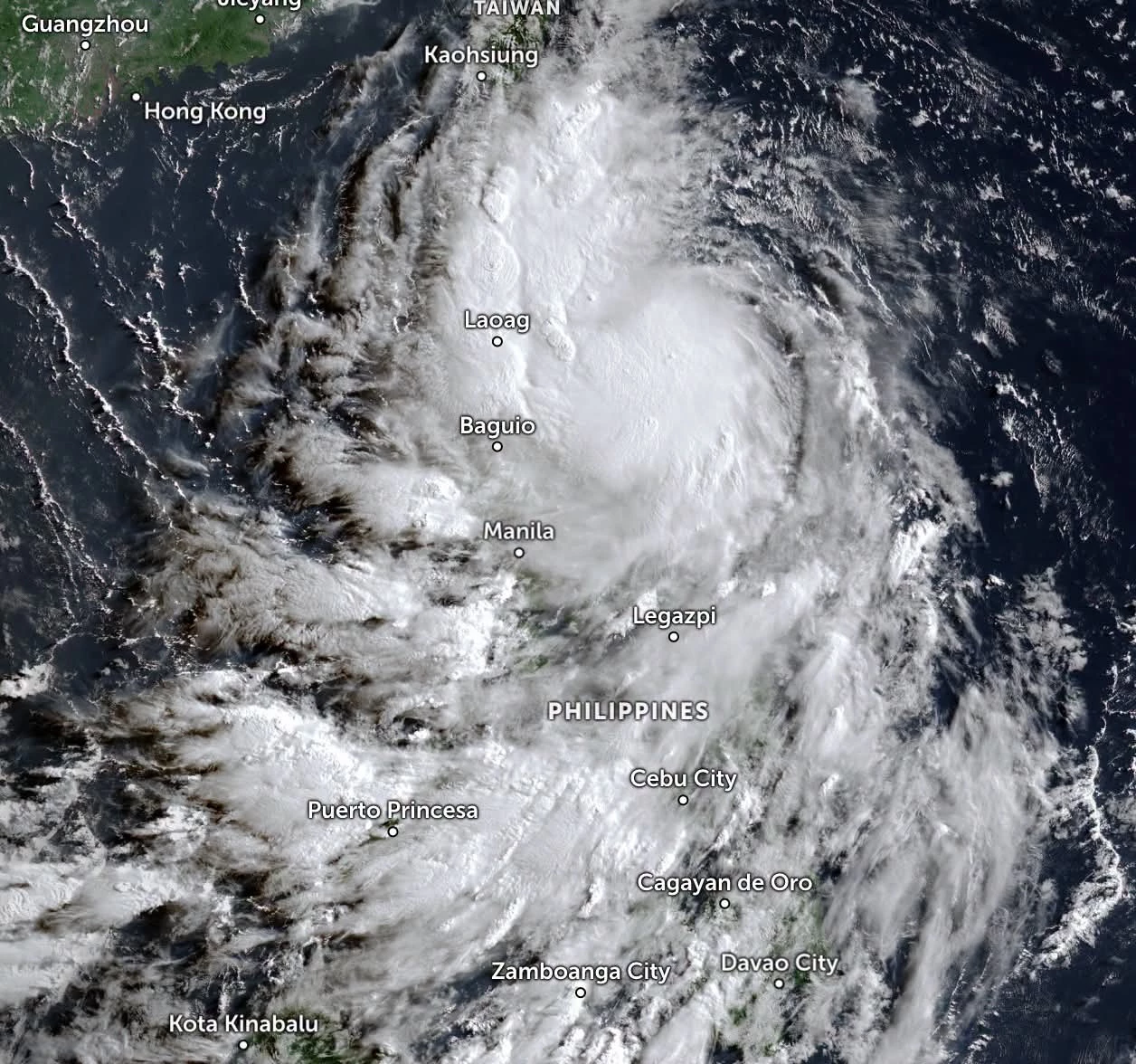
LOOK: Latest satellite imagery shows thick cloud bands covering a large portion of the Philippines as Tropical Storm #KiyapoPH (NOUL) continues to intensify the Southwest Monsoon (#Habagat) while heading toward #NorthernLuzon .
The cloud cover is thickest over #SouthernLuzon , #Visayas , and #Mindanao , where continuous rainfall is expected in the coming hours.
🌧 Expected weather across regions:
#NorthernLuzon – Rain and strong wind gusts caused by Tropical Storm KIYAPO.
#ZamboangaPeninsula, #Negros Island Region, Western Visayas, Lanao del Norte, BARMM, and SOCCSKSARGEN – Widespread rainfall caused by the enhanced Southwest Monsoon (Habagat).
#MetroManila, #CentralLuzon , #CALABARZON , #BicolRegion , #EasternVisayas , #Romblon , and #CentralVisayas – Cloudy skies with scattered to occasional rain showers due to the Southwest Monsoon (Habagat).
The public is advised to remain alert for potential flooding and landslides, especially in areas experiencing continuous rainfall.
#WeatherAlert #WeatherUpdate #KiyapoPH #Habagat | 24 July 2026
LOOK: Latest satellite imagery shows thick cloud bands covering a large portion of the Philippines as Tropical Storm #KiyapoPH (NOUL) continues to intensify the Southwest Monsoon (#Habagat) while heading toward #NorthernLuzon .
The cloud cover is thickest over #SouthernLuzon , #Visayas , and #Mindanao , where continuous rainfall is expected in the coming hours.
🌧 Expected weather across regions:
#NorthernLuzon – Rain and strong wind gusts caused by Tropical Storm KIYAPO.
#ZamboangaPeninsula, #Negros Island Region, Western Visayas, Lanao del Norte, BARMM, and SOCCSKSARGEN – Widespread rainfall caused by the enhanced Southwest Monsoon (Habagat).
#MetroManila, #CentralLuzon , #CALABARZON , #BicolRegion , #EasternVisayas , #Romblon , and #CentralVisayas – Cloudy skies with scattered to occasional rain showers due to the Southwest Monsoon (Habagat).
The public is advised to remain alert for potential flooding and landslides, especially in areas experiencing continuous rainfall.
#WeatherAlert #WeatherUpdate #KiyapoPH #Habagat | 24 July 2026

3

2 reactions
🚨 RED ALERT: The Blizzard that wasn't... or "How I forgot how maps work." 🗺️😅
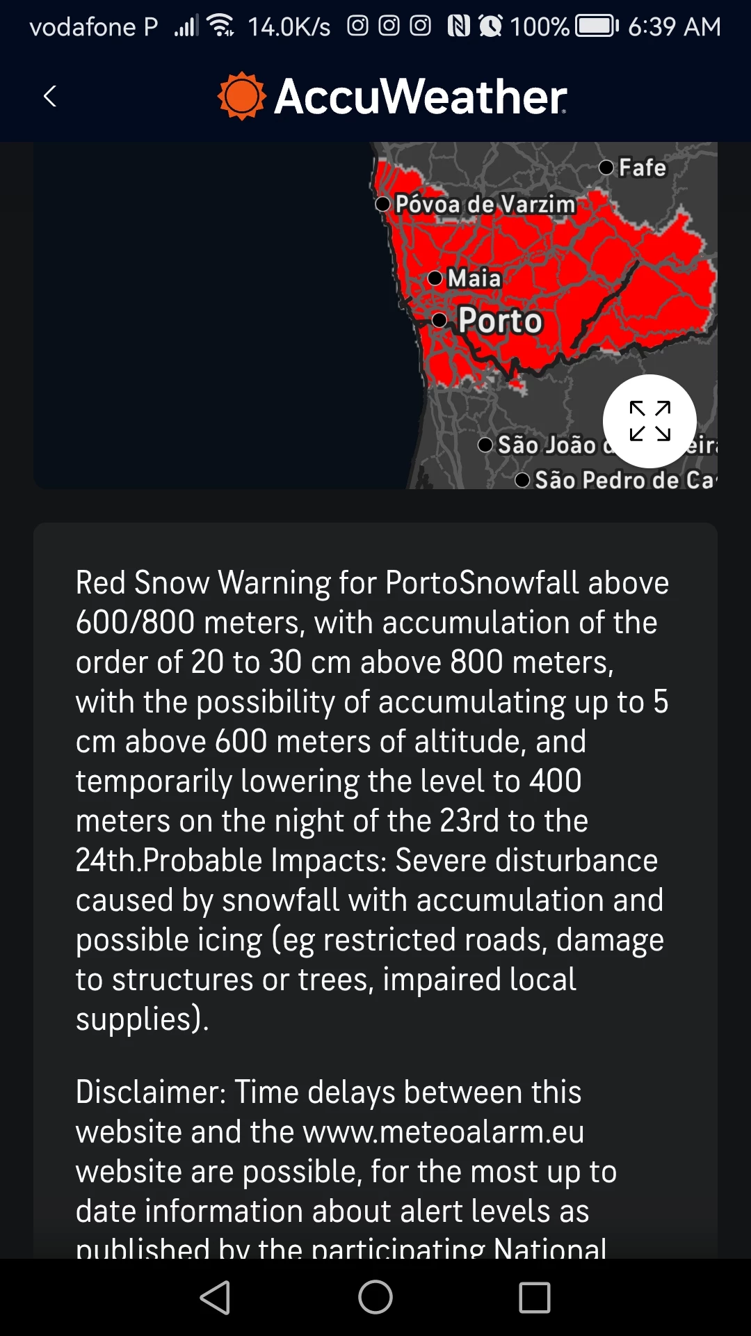
I woke up to this terrifyingly red map and a warning for heavy snow in my district (Porto). The alert says snow is coming for anyone above 400 meters.
Me, doing quick math: "Oh my god, I am 650 meters away from the beach! I'm going to build a snowman!" ⛄️🤩
...Then I remembered that altitude and distance are two very different things. 🤦♂️
Since I am currently at sea level on the Portuguese coast, my "snow" is unfortunately just 10°C rain and a very angry Atlantic Ocean battering the sea wall. So close to a winter wonderland, yet technically... a mountain away.
To anyone actually up in the mountains driving through "Depression Ingrid" today—stay safe! I'll just be down here fighting the wind with my umbrella. ☔️💨
#WeatherUpdate #Portugal #Porto #RedAlert #SnowDay (Not) #DepressãoIngrid #WeatherFail #CoastalLiving #TangledSocial #WinterStorm #StaySafe
I woke up to this terrifyingly red map and a warning for heavy snow in my district (Porto). The alert says snow is coming for anyone above 400 meters.
Me, doing quick math: "Oh my god, I am 650 meters away from the beach! I'm going to build a snowman!" ⛄️🤩
...Then I remembered that altitude and distance are two very different things. 🤦♂️
Since I am currently at sea level on the Portuguese coast, my "snow" is unfortunately just 10°C rain and a very angry Atlantic Ocean battering the sea wall. So close to a winter wonderland, yet technically... a mountain away.
To anyone actually up in the mountains driving through "Depression Ingrid" today—stay safe! I'll just be down here fighting the wind with my umbrella. ☔️💨
#WeatherUpdate #Portugal #Porto #RedAlert #SnowDay (Not) #DepressãoIngrid #WeatherFail #CoastalLiving #TangledSocial #WinterStorm #StaySafe
1

1